IDEF1X97 - A Spatial Extension
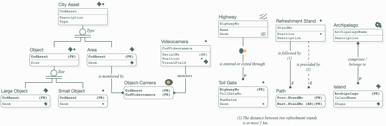
This is a non-standard extension to IDEF1X97 (ISO/IEC/IEEE 31320:2) to help you design spatial Relational databases (e.g., to be implemented with PostGIS or SpatiaLite). It provides icons for the most common entity geometries and topological relationships. It also adds a special relationship ending with a filled diamond (not to be confused with the empty diamond used in IDEF1X to denote an optional parent) to represent spatial aggregation (coverage + non-overlapping, e.g., an archipelago with its islands) or spatial composition (only coverage). Spatial categorization is easily modelled by annotating a standard categorization with spatial icons. Metric constraints can be specified as standard IDEF1X notes. Being a non-standard notation, feel free to use it as you see fit. IMPORTANT: set your canvas to use an 8pt grid for perfect alignment.